Habitat loss and fragmentation are the leading causes of species loss globally, and although Alaska is thought to be 95% intact (Trammell and Aisu 2015), the location and intensity can have important impacts on local and regional resources. However, a detailed, comprehensive dataset showing human development has yet to be created for the state of Alaska. We expect these datasets can inform numerous resource and land managers decisions including:
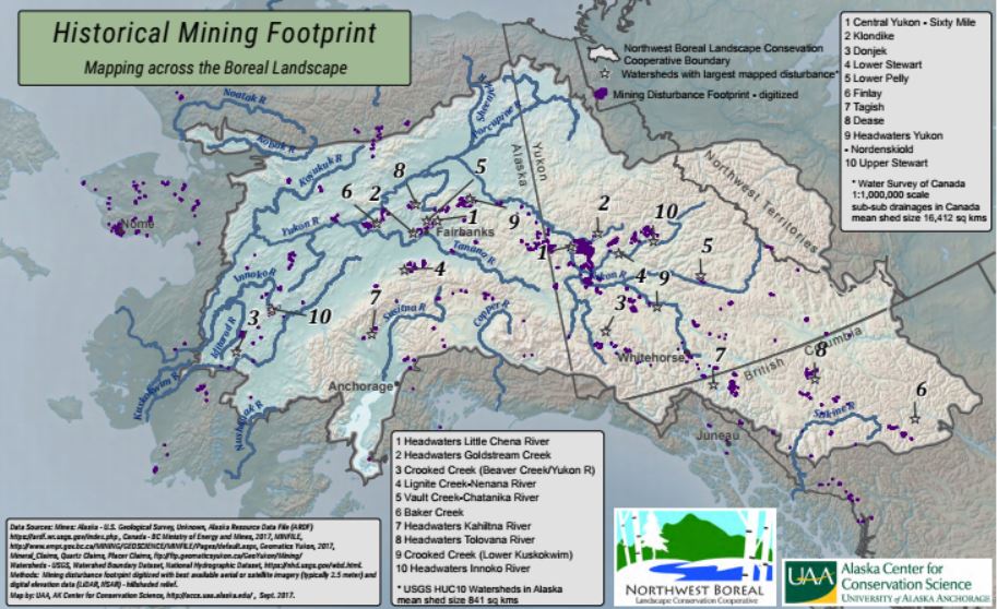
The team spent significant effort on developing a comprehensive dataset defining mining’s footprint across the region. Historically, mines have been depicted by point locations which do not convey their relative sizes or mining activity might be represented by claims polygons which overestimate their actual footprints. With the advent of statewide 2.5 meter ortho-imagery, ACCS embarked on project to digitize visible surface disturbance related to historic and current mining. Nearly 2000 source point locations were evaluated from the US Geologic Survey, British Columbia Ministry of Energy and Mines, and the Yukon Department of Energy, Mines, and Resources. The mining footprint dataset includes over 650 discrete polygons totaling 1200 square kilometers with a mean size of 1.8 sq kms. The measured mining footprints have been summarized at the watershed (USGS HUC10 – mean area 688 sq kms) scale across Alaska and summarized at the coarse scale, sub-sub drainage unit (mean area 16,000 sq kms) within Canada. This dataset could help inform decisions regarding natural resource monitoring, identifying potential mitigation/restoration sites, and for conservation planning at watershed scales. Additional human footprint datasets include a comprehensive transportation layer incorporating roads, trails, rails, and airports across the NWB LCC as well as and energy layer and a developed landcover layer. Project Details WHAT: This project assembled datasets representing the past and present human footprint across the Northwest Boreal Landscape. WHERE: Northwest Boreal LCC spans across almost 40% of Alaska, 90% of the Yukon, 20% of British Columbia, and 7% of the NWT. WHO: Alaska Center for Conservation Science staff gather data from federal, state, local, tribal, and non-governmental agencies. Duck Unlimited Canada contributed Candian datasets. DATA CITATION: Geist, M., M. Aisu , P. Lema & E. J. Trammell. 2017. Spatial estimates of surface mining footprints in northwest boreal ecoregions of Alaska and Canada. DATA CONTACT: If you have updated data and would like to incorporate your information into this footprint, please contact Marcus Geist at mageist (at) alaska.edu or 907-786-6325. WHY: The Alaska Climate Science Center and the Northwest Boreal LCC expressed a need for landscape scale datasets which can be used for habitat modeling, connectivity evaluations, and a means to more fully measure cumulative impacts. WHEN: The project began in 2014 with data updates through 2017. Comments are closed.
|
|
Thank You
The Northwest Boreal Partnership would like to thank our generous core funders: the Volgenau Foundation, Alaska Conservation Foundation, National Science Foundation, Network for Landscape Conservation, and the U.S. Fish & Wildlife Service. Photos for this site provided by U.S. Fish & Wildlife Service and Tanana Chiefs Conference. |
Learn More
Questions about the Northwest Boreal Partnership? Contact Us Join our e-mail list for newsletters and announcements! Sign up Here Learn more about our network of regional partnerships in the north: The Northern Latitudes Partnerships |
|
Copyright Northwest Boreal Partnership © 2021