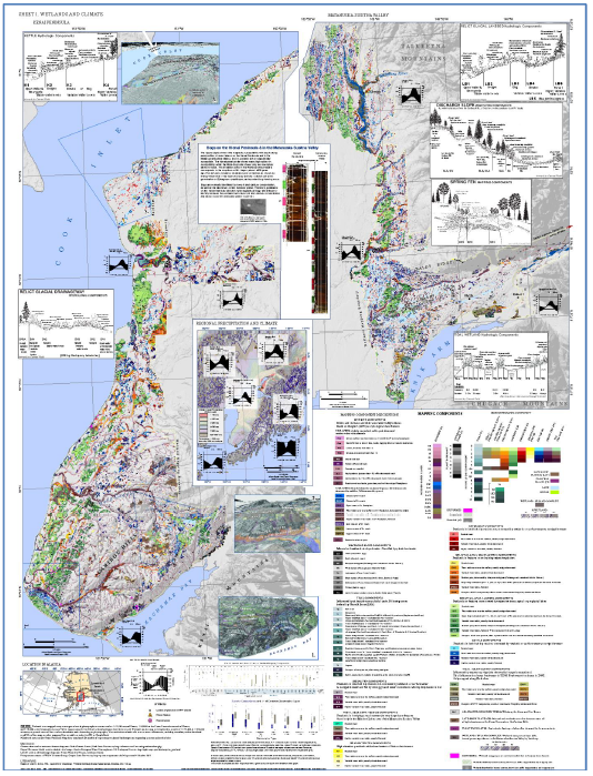
Habitat loss and fragmentation are the leading causes of species loss globally, and although Alaska is thought to be 95% intact (Trammell and Aisu 2015), the location and intensity can have important impacts on local and regional resources. However, a detailed, comprehensive dataset showing human development has yet to be created for the state of Alaska. We expect these datasets can inform numerous resource and land managers decisions including:
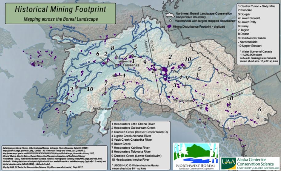
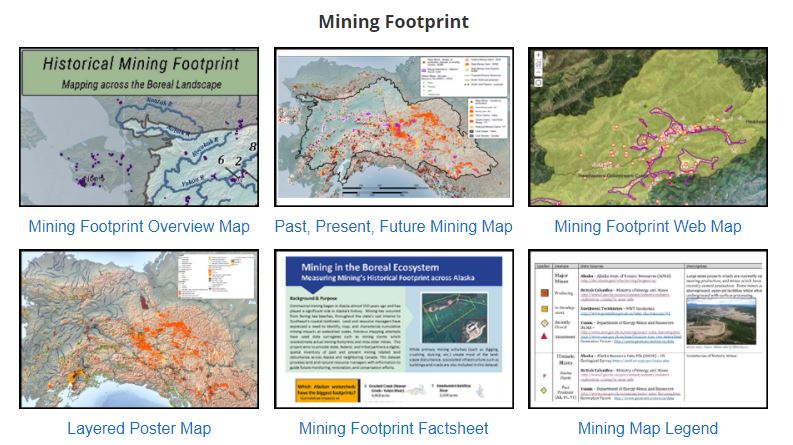
The team spent significant effort on developing a comprehensive dataset defining mining’s footprint across the region. Historically, mines have been depicted by point locations which do not convey their relative sizes or mining activity might be represented by claims polygons which overestimate their actual footprints. With the advent of statewide 2.5 meter ortho-imagery, ACCS embarked on project to digitize visible surface disturbance related to historic and current mining. Nearly 2000 source point locations were evaluated from the US Geologic Survey, British Columbia Ministry of Energy and Mines, and the Yukon Department of Energy, Mines, and Resources. The mining footprint dataset includes over 650 discrete polygons totaling 1200 square kilometers with a mean size of 1.8 sq kms. The measured mining footprints have been summarized at the watershed (USGS HUC10 – mean area 688 sq kms) scale across Alaska and summarized at the coarse scale, sub-sub drainage unit (mean area 16,000 sq kms) within Canada. This dataset could help inform decisions regarding natural resource monitoring, identifying potential mitigation/restoration sites, and for conservation planning at watershed scales. Additional human footprint datasets include a comprehensive transportation layer incorporating roads, trails, rails, and airports across the NWB LCC as well as and energy layer and a developed landcover layer. Project Details WHAT: This project assembled datasets representing the past and present human footprint across the Northwest Boreal Landscape. WHERE: Northwest Boreal LCC spans across almost 40% of Alaska, 90% of the Yukon, 20% of British Columbia, and 7% of the NWT. WHO: Alaska Center for Conservation Science staff gather data from federal, state, local, tribal, and non-governmental agencies. Duck Unlimited Canada contributed Candian datasets. DATA CITATION: Geist, M., M. Aisu , P. Lema & E. J. Trammell. 2017. Spatial estimates of surface mining footprints in northwest boreal ecoregions of Alaska and Canada. DATA CONTACT: If you have updated data and would like to incorporate your information into this footprint, please contact Marcus Geist at mageist (at) alaska.edu or 907-786-6325. WHY: The Alaska Climate Science Center and the Northwest Boreal LCC expressed a need for landscape scale datasets which can be used for habitat modeling, connectivity evaluations, and a means to more fully measure cumulative impacts. WHEN: The project began in 2014 with data updates through 2017.
Background information:
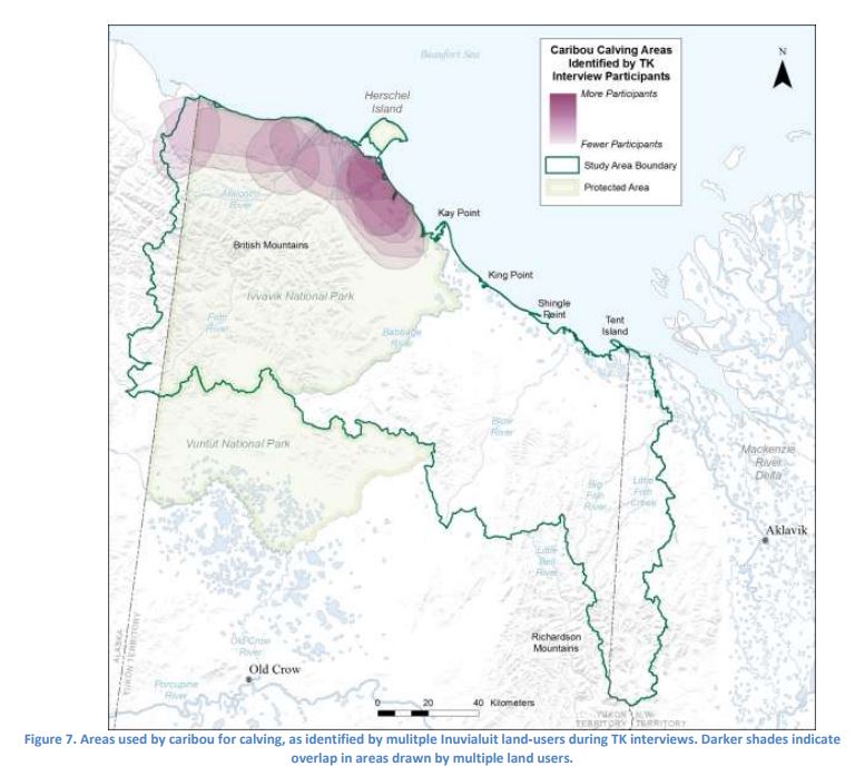
The Inuvialuit of the Yukon North Slope have formed a Wildlife Advisory Council, a co-management body, comprised of federal, territorial, and Inuvialuit representatives, and they are working closely with researchers from the Round River Organization to develop a management plan that reflects how the Inuvialuit use Arctic resources and their understanding of seasonal habitat use by fish and wildlife. This process for integrating Traditional and Western science in the Inuvialuit Settlement Area will provide an important example for how other scientists and managers can work with native communities to fulfill the need for wildlife and management plans in other places. Researchers reviewed existing local knowledge publications and recorded information from local workshops and interviews to develop detailed maps and descriptions habitat for caribou, moose, grizzly and polar bears, Dolly Varden Char, Broad Whitefish, geese, muskox and Dall’s sheep. Changes in distribution patterns and impacts from climate change have also been observed, especially for caribou. These changes include different migration routes and timing of migration. A report describing the knowledge gathered was submitted to the communities for review and use in the next phase of developing the management plan. The Inuvialuit Traditional Knowledge of Wildlife Habitat on the Yukon North Slope final report can be viewed here: http://arcticlcc.org/assets/products/ALCC2016-01/reports/Inuvialuit_Wildlife_Habitat_TK_Final_Report_20170712.pdf Documenting local knowledge of wildlife habitat and distribution promises to be useful and effective in managing wildlife by local users. This baseline wildlife assessment will inform multiple products including habitat models and connectivity mapping based on traditional knowledge and Western science data.
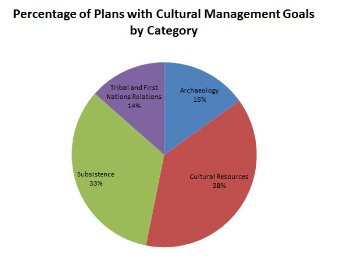
The review summarized and synthesized 120 management plan goals within the NWB LCC geography. Goals and objectives from each plan were categorized to enable comparisons across plans. These top-level categories were cultural, economic, environmental, and social. This review of regional management plans can be a useful resource for anyone interested in the region and how the goals of different land managers both overlap and diverge across the northwest boreal region.
A summary of the results and a full list of all of the management plans and their goals are available here: Summary document Full report and goal explanation
Abstract
Protected area networks are the foundation of conservation, even in northern Canada where anthropogenic impact on the landscape is currently limited. However, the value of protected areas may be undermined by climate change in this region where the rate and magnitude is high, and shifts in vegetation communities and associated wildlife species are already underway. Key to developing responses to these changing conditions is anticipating potential impacts and the risks they pose. Capitalizing on an existing modeled dataset for Yukon from Scenarios Network for Alaska and Arctic Planning (SNAP), we examine projected shifts in the distribution of 18 clusters of climate parameters, and the vegetation communities currently associated with them (collectively termed ‘‘cliomes’’) across three 30-year time steps, from the present through the 2090s. By the 2090s, Yukon may lose seven cliomes and gain one. Three regional changes, if accompanied by vegetation redistribution, represent biome shifts: complete loss of climate conditions for arctic tundra in northern Yukon; emergence of climate conditions supporting grasslands in southern Yukon valleys; reduction in climates supporting alpine tundra in favor of boreal forests types across the mountains of central and northern Yukon. Projections suggest that, by the end of the 21st century, higher elevations in southern Yukon change least when compared to the turnover in cliomes exhibited by the high latitude, arctic parks to the north. This analysis can assist with: planning connectivity between protected areas; identifying novel conservation zones to maximize representation of habitats during the emerging changes; designing plans, management and monitoring for individual protected areas. Read full article here.
The team is beginning by identifying and documenting databases that explain adaption efforts. They are conducting interviews and bringing together diverse groups. Funding comes from the Northwest Boreal Landscape Conservation Cooperative and the Alaska Climate Science Center.
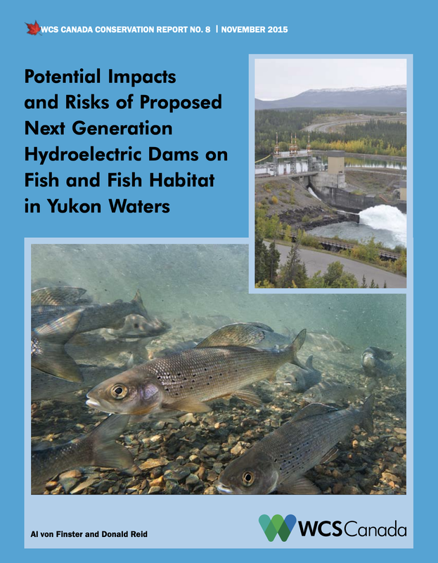
According to the lead investigator of the project, Douglas Clark, the objective is to identify the factors that facilitate or impede the development and spread of community adaptations to arctic change, by working with both the creators and intended users of existing databases that catalogue such adaptations. Observations to rule-based models that describe adaptation processes ranging from top-down agency planning to grass-roots community planning, will provide a framework to link community-empowered local adaptation with information and other resources available at larger scales. Through comparisons within and between adjacent jurisdictions in two arctic nations (Yukon, Canada and Alaska, USA) and the literature from other arctic nations, the project will assess factors that account for community differences in sensitivity to stressors and capacity to adapt. The team intends to work directly with the creators of those regionally-relevant databases and focus primarily on developing insights into the roles of (1) governance and institutional function and (2) management of renewable and non-renewable natural resources as key mediators of community adaptation. WCS Canada Conservation Report on Impacts and Risks of Hydroelectric Dams on Fish and Fish Habitat12/31/2015
|
|
Thank You
The Northwest Boreal Partnership would like to thank our generous core funders: the Volgenau Foundation, Alaska Conservation Foundation, National Science Foundation, Network for Landscape Conservation, and the U.S. Fish & Wildlife Service. Photos for this site provided by U.S. Fish & Wildlife Service and Tanana Chiefs Conference. |
Learn More
Questions about the Northwest Boreal Partnership? Contact Us Join our e-mail list for newsletters and announcements! Sign up Here Learn more about our network of regional partnerships in the north: The Northern Latitudes Partnerships |
|
Copyright Northwest Boreal Partnership © 2021